Our landscape, our history
Land use is often determined by the underlying physical environment, especially geology, topography and hydrology.
Here we take a high level view of the most important physical characteristics of Wiltshire, from which we may extrapolate why different regions came to be used in distinct ways. In particular, we focus on the Burton area.
Chalk and Cheese
The landscape of Wiltshire can be divided broadly into two types: Cretaceous chalk in the south and southeast of the county; and clay vales and limestone to the north and north west. This difference explains the epithet given to the landscape of Chalk and Cheese, as the chalk downloads support pasturing of sheep, while the the rich clay vales are suitable for dairy farming.
Geology
Wiltshire’s north and north west is a varied landscape including the clay vales and the limestone of the Cotswolds. The underlying geology of the area is mapped as early Jurassic (or Lias) rocks, the oldest rocks of the county. Above them is clay interbedded with shelly limestone of the Forest Marble series of the Middle Jurassic era.
The limestones, laid down in warm shallow shelf seas, are more or less horizontal producing an underrating plateau landscape. Deep valleys dissect it, cut by tributaries of the River Avon such as the By Brook.
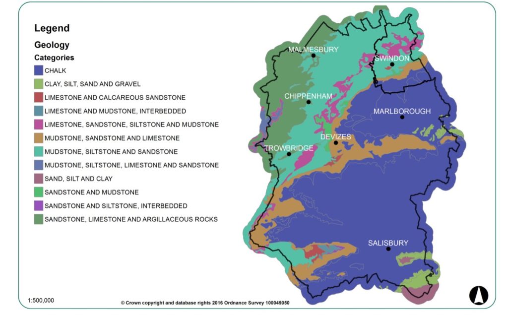
Locally, the area around Burton is underlain by limestone from the Chalfield Oolite Formation. Where eroded by the By Brook and associated waterways, limestone from the Inferior Oolite and Forest Marble Formations and mudstone from the Fuller’s Earth Formation are exposed.
Soilscape
The main soil types in the Burton area are a combination of lime-rich loamy and clayey soils with impeded drainage and shallow lime-rich soils over limestone (Cranfield University, 2023).

Legend
Shallow lime-rich soils over chalk or limestone: arable grassland.
Freely draining slightly acid but base-rich soils: arable and grassland.
Lime-rich loamy and clayey soils with impeded drainage: arable some grassland
Slowly permeable seasonally wet slightly acid but base-rich loamy and clayey soils: grassland and arable some woodland
Topography
Wiltshire’s topography can be divided into two distinct zones: the north and west relating to the clays with less rugged land and less dramatic landforms (with the exception of the Cotswolds) and the south and east where the chalk valleys and plateaus exist, with striking variations in landform but perhaps a more homogenous character of landscape.
Burton lies within the Cotswolds and the By Brook catchment area. Its topography is characterised by eroded river valleys. The By Brook and its tributaries flow steeply along its 19km length, from over 150m in the upper catchment to the west, to 60m at Slaughterford in the east, and then more gradually southwards to 25m at the confluence with the River Avon.
Hydrology
Hydrology is linked to the porosity of the bedrock. The northwest of Wiltshire has many more waterways than in the south.
The By Brook catchment covers an area of 111 km. By Brook was formerly the main headwater of the River Avon, before a major shift along a fault line in recent geological time altered the surrounding watercourses that previously drained into the River Thames to flow into the River Avon instead, creating a series of water-cut gorges and leaving By Brook as a minor tributary of a larger river.
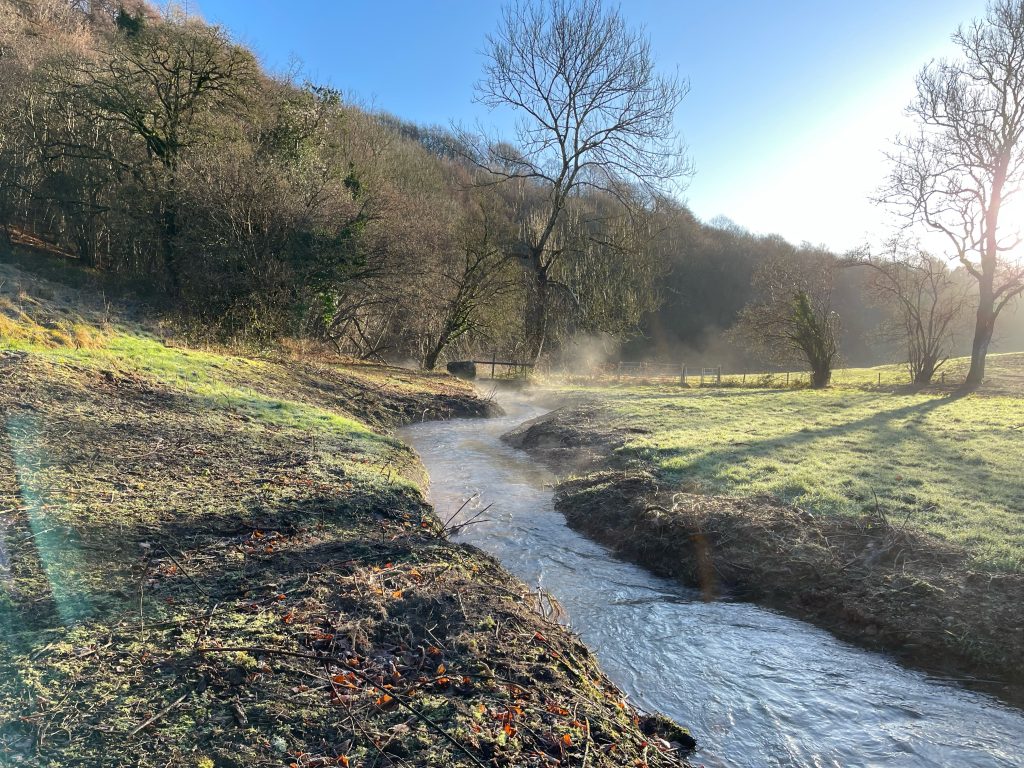
The Burton Brook (arising at Tormarton) and Broadmead Brook (arising at Cold Ashton) are the main sources of By Brook. Both flow from west to east across the By Brook catchment to join at Castle Combe. Downstream of this confluence, the mainstream By Brook flows down to the confluence with the River Avon. The main tributaries to the By Brook are an unnamed tributary that flows through Danks Down Wood near Ford, Doncombe Brook and Lid Brook.
The steepness of the By Brook dropping 200min 25 km from its highest point to its confluence with the River Avon, has given rise to its use to power watermills. The evidence of at least 20 mill sites has been found along the By Brook’s length.
Also in the Our Landscape, Our History series:
- Radicalism on the River: the By Brook’s nonconformist history
- Hydropower: a history of the By Brook
- Landscape Archaeology
For more on the history of Burton and its surrounding area, see here.
Bibliography
Brunner, Peter, et al. (2015) Feasibility Restoration Report for By Brook, North East Bath
Cranfield University (2023) LandIS. Available from: https://www.landis.org.uk [Accessed 25 March 2023]
Geddes, Isobel (2000) Hidden Depths: Wiltshire’s Geology & Landscapes. Cromwell Press, Trowbridge
Hannath, Steve (2014) Chalk & Cheese: Wiltshire’s rocks and their impact on the natural and cultural landscapes. ELSP, Bradford-on-Avon
Sunley, Tom (2016). The Wiltshire & Swindon Historic Landscape Characterisation Project Report. Available from: https://wshc.org.uk/our-services/archaeology/24-our-services/archaeology/250-historic-landscape-characterisation-project-downloads.html [Accessed 20 March 2023]

3 Comments
The History of Hydropower on the By Brook - Burton in Wiltshire · 03/26/2023 at 11:45 am
[…] from the Burton and Broadmead Brooks, the By Brook descends some 200m in 25km from its highest point to its confluence with the River […]
Radicalism on the River: the By Brook’s nonconformist history - Burton in Wiltshire · 04/07/2023 at 4:08 pm
[…] we have already seen, Wiltshire’s topography shaped its farming patterns and trade. Along with other factors, it also contributed to the spread of radicalism during the […]
Landscape Archaeology - Burton in Wiltshire · 04/13/2023 at 6:39 am
[…] out more about our landscape and how it shaped agricultural usage, industry and even political and religious […]