Burton – The Gibb – Castle Combe – Fosse Way – Nettleton – Burton
A moderately hilly ride to the east and south of Burton. 9.5 miles 520 ft (158m) climbing
Blog by Ian Wilson
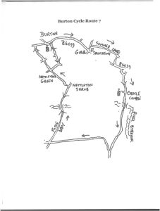
Burton Cycle Route 7
Check with the Wessex Water map of road closures as the Fosse Way may be affected at times.
Leave Burton heading eastbound on the B4039 then turn left at the Gibb cross-roads. Almost immediately turn into Summer Lane, just after the Salutation. The lane is quite rough, little more than a track, but is almost traffic-free, though be alert for other bikes as it’s on the Wiltshire Cycleway. At a minor cross-roads turn right, this lane soon rejoining the B4039. Turn left on the main road then almost immediately take a right. This starts the descent into Castle Combe. At the next T go right then continue down the hill into the village. There may be many walkers coming down from the car-park – warn them you are behind if need be.
At the market cross there are several refreshment options. Inside the church is a historic 15th century working clock, which has been brought down to nave level in modern times so it can be easily viewed. As always when visiting churches, a donation will be welcomed.
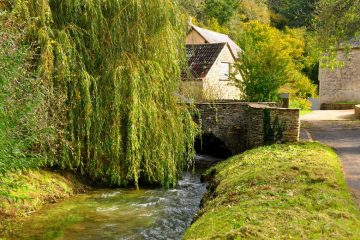
Continue down the village street which leads to the much-photographed bridge over the Bybrook. There are seats here by the river. For making the film Doctor Doolittle the river was dammed to mock up as a harbour, somewhat controversially. A young Ranulph Fiennes, of later exploration fame, let off a couple of home-made bombs in protest. A good old British summer defeated the film-makers and they retreated to the US having secured just 18 minutes of filming. Another refreshment option for those with (very) large wallets is the Manor House Hotel, the gateway to which is opposite. For anyone seeking the castle which gave its name to the village, it was further up the valley but there is little to see now, the stones reputedly having been raided to build the Manor House.
A lovely river-side stretch follows, then the road veers uphill away from the road. Where it does so a stone footbridge can be seen over the river. At one time there were suggestions it was Roman, though it’s hard to see why as the Romans always used semi-circular arches which these clearly are not.
A long hill follows, though the gradient is not too taxing. Towards the top turn sharply right into a side lane towards North Wraxall. The route skirts the top of a wooded valley then after a hairpin bend ascends into more open country.
At a cross-roads turn sharply right. It’s briefly quite steeply uphill so approach the crossing in low gear. This is now the Fosse Way which can be followed as in previous rides until Nettleton Shrub, where a left turn leads to Nettleton Green and hence back home via now-familiar lanes.
If you liked this, see more like it here.
0 Comments