Burton – Nettleton Green – West Kington – Drifton Hill – Gypsy Cross-Roads – Burton
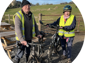
Ian & Ann Wilson (credit: Lee Jane Hawkes)
7.5 miles, 490 ft climbing (150m)
Blog by Ian Wilson
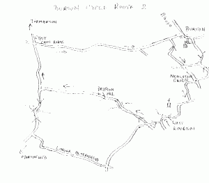
Download map
This is a short ride but including some fairly steep though short hills. A slightly longer alternative is indicated.
Head west on the B4039 then at the end of the village bear left (virtually straight ahead) on Toll Down Road (unsigned). In 200 m turn left in to Edgecorner Lane which starts steeply but soon eases. At the top the road kinks sharply left (presumably the origin of its name) then follows a gradual descent to a cross-roads (give way). Straight across then a modest climb leads to Nettleton Green. Residents of the higher part of Burton may prefer to take Nettleton Road to reach the same point.
Turn right at the triangle down an unsigned road. After half a mile, right at the next T. The lane soon passes West Kington Stud where in summer many foals may be seen. The church is prominent, access being through the farmyard or by a steep footpath from the village. The road now descends steeply, crossing the bridge at the bottom, a lovely spot with its stream, stone bridges and fine houses.
Something else you now discover about West Kington is that every road out of it is up. Take the right option which immediately ascends a moderate gradient. At a cross-roads turn right. For the longer option continue straight ahead, past the chapel, then in a mile right at a cross-roads. After a further mile, right at a T joining the fairly busy Marshfield- Tormarton road. After a steep dip and corresponding ascent the described route rejoins from the right.
After the right turn at the cross-roads you lose all your hard-earned height! Cross the bridge, the hill starting innocuously with the stream on the left, but a short steep part of around 1 in 7 is soon reached. Then follows a rather featureless long, straight ascent, with derelict barns giving a feeling of desolation, and often a headwind as well. Eventually the lane dips and ends at a T. Turn right and follow an easy climb to the highest point on the ride at a small copse. After a straight downhill stretch turn right at the Gypsy Cross-roads (take care, following traffic can be coming up fast here). In non-Covid times diversions for lunch can be made here, straight on for the Major’s Retreat or left for the Crown, each about a mile from the route.
Now comes the reward for those climbs – idyllic cycling back to Burton, losing 200 feet with just a few tame rises on the way home and often a tailwind as a bonus. It is hard to appreciate this was once a trunk road in the horse-drawn era and until recent years there were still stone mileposts giving the distances to London. Indeed one still survives in Grittleton but off this ride.
If you liked this, see more like it here.
1 Comment
Lee Jane · 01/21/2022 at 8:48 am
Amazing couple, I hope I’m still cycling at their age.