Photographic Views of Burton
Author: Chris Bennett
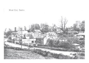
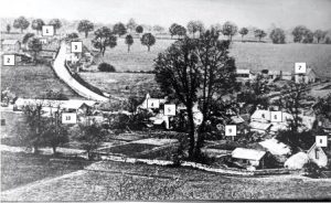
This blog takes a look at landscape views of the village from a pair of photographs dating to around the 1930s.
West End, Burton

The properties shown are:
- The Laurels; we believe the owner was a man called Mr Higgs who was a coal merchant and well known for driving around in the rather stylish car seen parked outside on the road.
- A shed/garage which apparently had a petrol pump inside, this is now a house called West End Bungalow.
- An old forge, now part of Lower Cottage. There were other working forges in the village to serve the agricultural needs of the area.
- A row of five cottages with the barber’s shop at one end, today we now have only three extended properties called, Hunters Cottage, Meadow View and Brookside Cottage.
- New House Farm (as featured in the July edition).
- An old cow shed (part of New House Farm).
- Lower Cottage.
- The Coach House.
- The Old Rectory (outbuildings).
- The Old Rectory.
- Top Cottage.
- St Mary’s Church
- Agricultural buildings, (known locally as The Limes, as there was a row of lime trees along the road), they were used for chickens and storage of hay, etc. These buildings were also part of The Laurels owned by Mr Higgs. This area is now part of the housing development Toll Down Way.
This area is now part of the housing development Toll Down Way.
Hillside and The Street

The properties in view are:
- Hillside Cottage.
- Tyning View, today this area also includes a transport yard (according to Wikipedia the word Tyning is a name-element occurring commonly in north-east Somerset – most of all in the Bath area, and over the borders into Wiltshire and Gloucestershire. It is used for woodlands of several farms. The word may also be derived from the meaning to “enclose with a hedge or fence).
- Summers End and no’s 1 & 2 Hillside Cottages.
- The Laurels.
- Top Cottage.
- The rear of the five cottages on The Street.
- West View and a number of small outbuildings.
- An old barn and farm buildings (believed to be part of New House Farm)
- Lower Cottage
- Agricultural/farm buildings (part of The Laurels) which are now part of the houses of Toll Down Way
- In the foreground of the photograph close to (5) you can clearly see some form of cultivated area, providing allotments or vegetable gardens for nearby houses.
Acknowledgements
With thanks to Tony & Pauline for providing the photographs and, along with other residents, assisting with the identification of particular buildings.
This blog was published previously as an article in The Bugle, as part of its Historical Burton series, and was written by Chris Bennett.


0 Comments